

Birth of Portuguese Bend
15 million - 100 million years ago
Long before multi-million dollar mansions dotted the terraces, long before bluff erosions and landslides shaped the topography and rerouted our roads, long before World War II required building bomb shelters and missile sites, long before a New York banker purchased 16,000 acres of the land sight unseen for $1.5 million, and long before Portuguese whalers harpooned their prey and scrabbled up the cliffs in search of shelter and a hot meal, and millions of years before a quiet indian tribe dwelt among the bends, coves, and rolling hills, the entire Palos Verdes peninsula was submerged under the Pacific Ocean as part of a broad submarine ridge.
The Portuguese Bend region is the largest area of natural vegetation remaining on the Palos Verdes Peninsula, in Los Angeles County, California. Though once slated for development (and in fact the projected route of Crenshaw Boulevard through the area still shows on many maps), the area is geologically unstable and is unsuitable for building.
The geographical location and geological history of the peninsula make the remaining habitat extremely valuable for ecological and other scientific reasons. The peninsula, which was an island with the Palos Verdes Hills in recent geological time, has close floral and faunal similarities to the Channel Islands. This feature makes the Portuguese Bend Landslide area a natural research laboratory for the study of island biogeography and evolutionary ecology.
If you had been a dinosaur roaming the western United States around 65 million years ago, right before that meteor slammed into the Yucatan Peninsula, you would not have been able to recognize Southern California. Much of it was underwater.
At that time, far offshore, there was a plate tectonic spreading zone called the East Pacific Rise, complete with an island arc of volcanoes. To its west, the Pacific Plate was moving to the west and north, as it does today. But to the east, there was a plate called the Farallon Plate moving toward and subducting under North America. Much of the uplift that characterizes the American West began as the Farallon Plate dove beneath the North American plate. It was about 30 million years ago that the North American plate completely covered up the Farallon Plate. This put the North American Plate in contact with the Pacific Plate and gave birth to the San Andreas regional system of faults.
This geological convergence completely changed the region. As the two plates came in contact with each other, bits and pieces of land (terranes) broke off from the North American Plate. Among the stresses and strains was the creation of the Palos Verdes anticline, a chunk of rock sediments compressed upward along a spine running southeast to northwest. It is the buckling up of this feature that pushed Palos Verdes up out of the ocean floor. In fact, it pushed Palos Verdes up so fast that it eventually became an island, just another one of the Channel Islands, as the Los Angeles basin remained under water.
Palos Verdes island began to connect with the mainland sometime during the Pleistocene, the era of repeated ice ages and ocean level drops over the last couple million years through this combination of renewed uplift and filling in of the shallow seas to the north and east. The speed at which Palos Verdes uplifted is fast by geologic standards and has resulted in the development of an impressive stairway of 13 marine terraces on the PV coast.
The terraces are created by wave action against the shoreline. The ocean’s waves cut into the coast, creating cliffs with a wave-cut notch at the base. The notch then expands under the cliff, and the cliff will eventually fail as its support gives way.
If tectonic uplift accelerates again (or if an ice age pulls up so much water that ocean levels drop), the cliff and the bench below it are hoisted up above the reach of the waves. Eventually, erosion and mass wasting of the area at and above the cliff will drop alluvial materials over the cliff and onto the bench. This new structure may itself be hoisted higher as the process repeats. In Palos Verdes, this has happened at least 13 times in the last 2.8 million years. The visibility of these terraces indicates that the process is going on so fast that it can’t be hidden by erosion and deposition smoothing away the surface evidence.
One big consequence of all this uplift is landslides. In Palos Verdes, the land is rising so fast that the land is unable to resist the downward pull of gravity. Lots of places in Southern California are uplifting quickly but not all of them are slipping as fast as Palos Verdes. PV has some special complications, which have a lot to do with its geologic history.
Another complication was the outburst of vulcanism back in the Miocene era about 20 million years ago. Some of these volcanoes sprinkled basalt all over PV. Much more important to landsliding, however, was the spewing of volcanic ash and cinder, which formed a rock called tuff. In some places tuff formed as much as 15 meters thick.
Subsequent interactions of tuff with water (in marine deposits later uplifted or rain, groundwater, or hydrothermal action) caused the tuff to interact with water and undergo chemical alteration into bentonite clay. Bentonite swells when exposed to water and becomes a kind of greasy glop, not what you need when that glop layer is supporting the weight of layer upon layer of heavy rock above. The presence of Portuguese tuff and bentonite layers amid the Miocene Monterey Formation sediments creates lubricated layers that can enable a large chunk of overlying terrain to slide as coherent units down a slide plane.
There is a gigantic slide that was active about 37,000 years ago, which is locally called the “Ancient Landslide.” This landslide stabilized for a long time. Its upper layers then reactivated in 1956, after Rolling Hills was developed and suburbanites put in septic tanks and lines and began irrigating their lawns. This human activity apparently introduced enough extra water into the bentonite layers to detach the landslide along a plane higher up than the original Ancient Landslide. About 270 acres have moved around 600 feet toward the sea over the last half-century. This is the Portuguese Bend Landslide.
The Gabrielinos were of the Shoshonean family, and relatives of the Hopi Indians. They were also related to the Chumash tribe that eventually settled in and around Santa Barbara. The Gabrielinos that lived in Palos Verdes were described as gentle, friendly, and prosperous seafarers, fishermen, and traders. They were a people of strong family ties, and lived in close knit groups.
These Gabrielinos spent much of their time to building twelve to sixteen-foot canoes, which they used for fishing and commuting to Catalina Island.
.jpg)
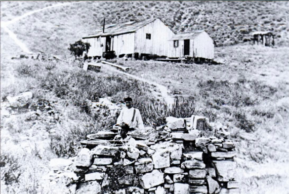
Archeological evidence supports the existence of Gabrielino clans, and larger family groups, all over the peninsula but clustered around San Pedro Bay, Cabrillo, on the hills above Channel and Gaffey, and at Whites Point. There were also discoveries of possible village sites at the present-day Palos Verdes Reservoir and Portuguese Bend. During construction of a parking lot for the new Abalone Cove Club, west of Portuguese Point, a large kitchen was found and numerous items uncovered including an intact skeleton.
There is no doubt that much more about the Gabrielinos still remains buried in Palos Verdes.

Sources: “Time and Terraced Land,” by Augusta Fink, “Peninsula Past,” by Betty Lukas and Marjeanne Blinn, "Rolling Hills: The Early Years," by A.E. Hanson, “The Palos Verdes Story,” by Delane Morgan, Palos Verdes Review, 1982. "Quick Overview of Palos Verdes Geological History and Landslides, by CSULB Rodrigue research paper, Palos Verdes Geology.
Portuguese Bend Club, Then and Now by Sue Kersey, Docent, Point Vicente Interpretive Center, January 1988
Portuguese Bend Club Recollections, Research Series #383, by Don Eichhorn, March 2015
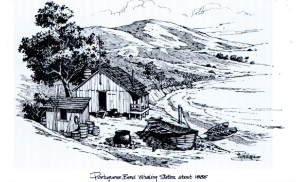
Piotrowski, Dennis & Sugimoto, Monique (2015, October 28). Portuguese Bend thrived as a whaling station. Palos Verdes Peninsula News. Retrieved from https://www.pvnews.com/opinion/portuguese-bend-thrived-as-a-whaling-station/article_1fb586f0-7db8-11e5-b267-03814f185378.html
Piotrowski, Dennis & Sugimoto, Monique (2019, October 31). Meet Portuguese Charlie, the famous fish cook of Portuguese Bend. Palos Verdes Peninsula News. Retrieved from https://www.pvnews.com/lifestyle/meet-portuguese-charlie-the-famous-fish-cook-of-portuguese-bend/article_2d3d32b8-f9b6-11e9-973d-5f6933508d35.html